Consultants’ plan for Hwy 1 lacks awareness of our environment and community

"Essential Characteristics of Roundabouts" form the consultant's plan
Letter

By on Fri, February 26, 2010

NOTE: This was originally posted as a comment on an earlier story. We’ve republished it as a letter in order to spark some conversation about the proposal.

Absent from the recent "Traffic & Trails" outside consulting effort last year were:

  1. An awareness of the coastal environment in general—what it means to be "coastal"—and our local coastal environment in particular.
  2. An awareness of the California Coastal Act and our LCP.
  3. An awareness of the history and character of our local communities.
  4. An awareness of the numerous past considerations of vehicular and non-vehicular transportation in our area.
  5. An awareness of the essential natural and financial resources of our area, in concert with what development our area can absorb without being degraded.

What we saw was a set of "principles", etc., for imposing the designs of landscape architects and community planners on, essentially, a blank slate.

In every example of their work elsewhere, we saw designs that resulted in greater development and the increased hardscaping that goes with it. These people are for increased building and pavement—at least that is what their designs show. They do not know the physical difference between a road and a trail. They don’t recognize huge energy and pollution costs of industries involved in implementing their designs—for example the cement industry.

Some of their ideas would come close to creating de facto transportation corridors and hubs that would exempt, via last year’s SB375, surrounding new development from vital environmental regulations and reviews. Such simple matters as their prolific use of tree "walls" in their designs would block coastal views in El Granada that some residents have rightfully fought to preserve for decades. (There were no native trees on our coastal terrace.)

Rather than restore the now-parking-blighted Burnham Strip to the community commons it was originally laid out to be, they would cut off edges of it for widened roads. The runoff from the additional paving in their designs would add to the problems we already have, further degrading some local creeks into the storm sewers they are becoming.

Now I’m well aware some locals, including our urban environmentalists, like the idea of turning the midcoast into a putatively-"upscale," artificially-designed suburbia, not unlike some of the planned and paved-over coastal communities created or retrofitted in Southern California and Florida. But I’m hoping those who appreciate the remaining coastal character of our communities and who prefer to live more in harmony with our area rather than institute ever more expensive efforts to dominate it will push for genuine improvements to our roads and trails and not fall for this setup for further urbanization.

It is difficult to see this consultant’s work as anything more than justification and a step toward the overdevelopment our county supervisors are trying to foist on us in their (so far unapproved) revised LCP worded for the benefit of their developer and builder buddies.

Brown pelicans are still imperiled in mysterious die-off

Brown pelicans in a pool at the Internation Bird Rescue Research Center, in 2009

By on Fri, February 26, 2010

Reprinted from Newsdesk.org

For the second straight year, the much-loved California Brown Pelican population is experiencing a mystifying die-off.

It’s a mystery,” said Dana Michaels, a spokeswoman for the California Department of Fish and Game, She is quoted in the Mercury News as saying, “It’s tragic. It’s very sad to see these poor birds suffer,” she said “I hope we can get to the bottom of it. There’s something really endearing about pelicans.”

Indeed, the pelican is the inspiration behind one of the most-quoted limericks of all time:


A wonderful bird is the pelican,
His bill will hold more than his belican,
He can take in his beak
Enough food for a week
But I’m damned if I see how the helican!

—Dixon Lanier Merritt, 1910

DFG wildlife biologist Esther Burkett said, in a report in the Chronicle:

“We think it’s probably related to El Niño and the big storms. “When the ocean gets all mixed up, the fish are moving around and the birds cannot find them. The majority of birds we found were just weakened by the lack of food.” The pelicans began turning up sick and dead in odd places throughout California and Oregon in mid-January. The wave of starving and emaciated pelicans overwhelmed the International Bird Rescue Research Center in Cordelia, which took in about 400 pelicans at its two branches. Many of the ill pelicans were waterlogged and suffering from hypothermia, problems that normally occur during oil spills.

A similar die-off occurred in 2009. The birds had been spending time off the coast of Oregon when a severe storm hit, driving the birds south and inland, fleeing the winds and freezing temperatures. Many of the birds recovered by rescuers showed signs of frostbite on their feet and pouches, suggesting that the birds were indeed unprepared for the unusually harsh conditions.

The pelican has had a precarious time of it in recent years, according to a report in Scientific American.

Brown pelicans are a rare endangered species success story. Once ravaged by the effects of DDT, the brown pelican was formerly protected under the U.S. Endangered Species Act. But decades after DDT was banned in the U.S., pelican populations have rebounded, and the bird was removed from the endangered list last November. The current population is estimated at around 650,000.


MROSD approves purchase of 160 acre property in Half Moon Bay

Press release

By on Fri, February 26, 2010

The Midpeninsula Regional Open Space District’s board of directors approved purchase of a 160-acre property in Half Moon Bay at a public meeting Wednesday night. The seller, a private party, will retain ownership of the adjacent property which includes their working Christmas tree farm. Less than two acres of the tree farm is on the land the District is purchasing, and will be leased back to the seller to be operated as part of the tree farm.

The property is located near Highway 92 and Skyline Boulevard, an area identified as a priority for land conservation because it serves as a gateway to the San Mateo County Coast. The District’s purchase of the property helps to preserve agriculture, rural character and scenic beauty of the Half Moon Bay area. Protection and restoration of the natural environment are also a priority for the District, and the purchased property provides rich and diverse habitat for wildlife.

Because the property is surrounded on all sides by private land, it will remain closed to the public for the time being. Future land purchases will be necessary to connect it to the District’s existing Mills Creek Open Space Preserve, less than a mile away. 

Weather service warns of gusty winds


By on Fri, February 26, 2010

The National Weather Service forecasts gusty winds until 9pm Friday night. This could result in power outages.

Strong winds along with periods of heavy rain will likely make travel difficult at times. The combination of wet soils from recent rainfall along with very windy conditions will likely cause downed trees. This could lead to local power outages.

Big Wave site visit cancelled

Breaking news

By on Wed, February 24, 2010

The county Planning Commission has cancelled its planned visit to the site of the Big Wave development.

The cost of updating the project’s draft Environmental Impact Report has caused a cascade of delays. Because the consultant requires more money to complete the EIR, the release of the final report has been delayed. The Planning Commission has delayed its scheduled March 10 hearing until the final EIR is completed.  This led the developer has delay putting up story poles until the minimum 10 days before the hearing, and the Planning Commission has delayed its site visit until the story poles are erected.

HMB resident wins Open Space District photo contest

Randy Weber
Fall Colors at Purisima Creek [Grand Prize Winner]
Karl Gohl
Open Space Ride, Russian Ridge, [Honorable Mention]

By on Wed, February 24, 2010

Randy Weber of Half Moon Bay won the grand prize in the Midpeninsula Regional Open Space District second annual digital photo contest.  Weber is an avid photographer who frequently hikes and bikes in the Purisima Creek Redwoods Open Space Preserve. There are more winning photos at the MROSD contest page linked above and more contest entries in a Flickr gallery.

Photos: Jan 20 storm in La Honda

La Honda Fire Brigade

By on Wed, February 24, 2010

The La Honda Fire Brigade has posted an album of dramatic photos of the impact of January’s big storm on their community.

Raptor Identification Workshop and Wavecrest Bird Walk, Saturday

image
Steve Jurvetson
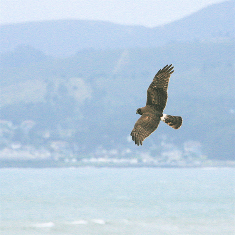
Female Northern Harrier hunting over Half Moon Bay
Letter

By on Wed, February 24, 2010

Raptor Identification Workshop

Saturday, February 27, 1:00 - 2:30 p.m.
At the Train Depot, 110 Higgins Canyon Road, Half Moon Bay

Please join us for an exciting workshop led by Alvaro Jaramillo, local biologist, life-long birder, eco-tour guide to the Americas, and author of Field Guide to the Birds of Chile and New World Blackbirds. Come learn about the Coastside birds of prey: hawks, eagles, falcons, kites and owls. Study field marks, behavior, ecology and migratory patterns. Find out how to tell them apart and where to locate them. Light refreshments will be served.

Wavecrest Bird Walk


Saturday, February 27, 3:00 - 6:00 p.m.
Meet at Smith Field at the end of Wavecrest Road, Half Moon Bay

Come stroll through this beautiful bluff top open space, lead by Alvaro Jaramillo and Gary Deghi, HMB wildlife biologist, environmental consultant and Sequoia Audubon member. Apply your workshop skills and identify birds and other wildlife. Warm beverages and cookies will be served at the end.

Suggested donation for Workshop: $15, seniors $5, under 18 free.
Wavecrest Bird Walk: free. Bring binoculars, dress in layers and wear sturdy, waterproof shoes.

For more information: 650.726.5056 or [email protected]
coastsidelandtrust.org

Draft wildfire plan ready for comment

image
Detail from the Community Wildfire Protection Plan

By on Tue, February 23, 2010

The preliminary draft of the Community Wildfire Protection Plan of San Mateo and Santa Cruz Counties is available for comment.  

This CWPP attempts to identify wildfire hazards in our region and provide strategies to mitigate risk and restore healthier, more resilient ecosystems.  It is also a tool to obtain grant funding to aid in the implementation of local wildfire prevention projects.

The plan is available at www.sanmateorcd.org/cwpp.html or you can download the relevant portions from Coastsider.

Public comments will be accepted until 5pm on Friday, March 19. Cal Fire will integrate comments into a final draft by March 31.  You can email your comments to [email protected].

More information about the CWPP is available on their blog: http://wildfireplan.blogspot.com

Charts:  Mavericks made Hwy 1 largely impassible in the afternoon

image
Caltrans data, Chart by League for Coastside protection
image
Caltrans data, Chart by League for Coastside protection

By on Tue, February 23, 2010

Nothing in these charts is likely to surprise Coastside residents, but we thought we’d share the data in case you were wondering just how bad traffic was during Mavericks.

The answer: Highway 92 never got too bad. But Highway 1 on the Coastside was mostly unusable that afternoon—even between Montara and Pacifica, which is typically not too bad even at the worst of times.

Page 7 of 79 pages ‹ First  < 5 6 7 8 9 >  Last ›