A slippery slope: The Devil’s Slide in 1983
| Year | Days closed |
| 1941 | 11 |
| 1967 | 15 |
| 1980 | 7 days closed + 31 days limited |
| 1983 | 84 |
| 1995 | 150 |
| 2006 | ? |
When Highway 1 over Devil’s slide was opened in 1937, the new road was a welcome relief after the winding mountain path previously used to go between the Coastside and Pacifica.
However, it was unstable from the beginning, built on slippery shale resting on solid granite. Shortly after it was built, the state highway department wrote, "It is anticipated that considerable trouble will be experienced by our maintenance forces during the next two or three winters, in keeping the roadway clear of minor slides and the natural sloughing of material from the steep mountain slopes." In 1941, the road was closed for eleven days.
That was the beginning. The road would be closed dozens of times in years to come and would drop nearly 50 feet from its original elevation. In 1980, the Slide would be closed completely for seven days, and then for 31 days only one lane was open during the day and all lanes were closed at night.
This March nearly set a record month for rain in San Francisco, with 8.74 inches. That record was set in 1983, with 9 inches. Mike Wong, who opened Spring Mountain Gallery in Half Moon Bay in 1980, recalls the night of March 3, 1983, "It was the worst rain I’ve ever seen, even worst than this year. I remember the night that all the desvastation took place. We knew everything was washing in around us. It was one spooky night. The rain was relentless."
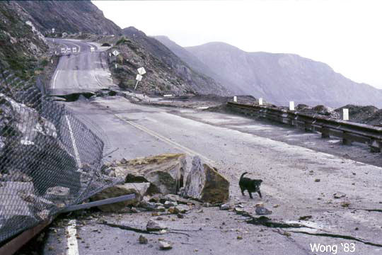
A 300-foot section of the road began to break loose that night. Caltrans closed the highway. It would stay closed for 84 days. Mike has provided us with some dramatic photos of that event that make this year’s slippage seem minor in comparison. The originals are only a little larger than the ones you see here, but you can open them by clicking on the images.

|
|
Mike Wong
|
|
A 300-foot section of the roadbed broke loose on March 3, 1983
|

|
|
Mike Wong
|
|
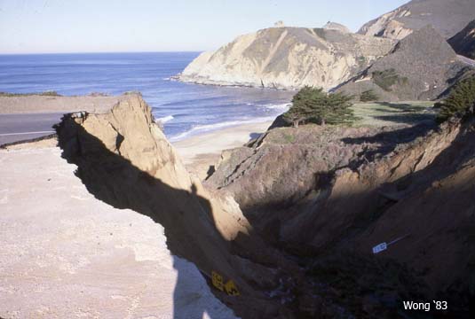
Highway 1 over Martini Creek at the north end of Montara State Beach was also washed out.
|

|
|
Mike Wong
|
|
Meanwhile, the cliffs below below what was then the Chart House were heavily eroded.
|
Click the link for more photos.
|
|
Mike Wong
|

|
|
Mike Wong
|

|
|
Mike Wong
|

|
|
Mike Wong
|

|
|
Mike Wong
|

|
|
Mike Wong
|
|
|
Mike Wong
|

|
|
Mike Wong
|
I drew on a number of sources for this article, but one important one was Eric Rice’s excellent three-part article on the history of the bypass controversy that originally ran in the Half Moon Bay Review in 2001, and reprinted on the Committee for Green Foothills website.