UPDATED: We have created an album of all our photos from the slide, which we will continue to update. You should still start with this article, because the captions will put it in perspective, but you can click here to view the album of all our photos.
We went up past the barriers to see what was happening on the Devil’s Slide. The action has moved from the subsiding roadway near Pacifica to the Slide itself, where Highway 1 was closed in 1995.
When the slide was repaired in 1995, sensors were installed in the roadbed to measure when the earth started spreading the road again. That’s what’s happening now. The lights that are connected to the sensors came on late last week and a few more times before CalTrans closed the road Sunday night.
CalTrans personnel on the scene told us that they won’t be able to do anything until the rain stops and the cliff stops sliding.
Click on the pictures for a larger version.

|
|
Barry Parr
|
|
Approaching the slide location from the north, you first see the warning lights that a few drivers have seen in the past few days. The lights are activated when sensors in the roadbed indicate it is widening. The orange circle shows where the cracks have appeared in the road.
|

|
|
Barry Parr
|
|
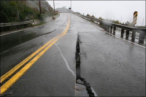
The crack nearest the ocean shows indications of recent efforts to fill it in. The faint white paint line moving to the upper left corner of the photo is a paint line that shows where the slide is separating.
|

|
|
Barry Parr
|
|
The middle crack is about as wide as the yellow stripe on the highway and follows a seam in the asphalt. It goes down about 10 inches to below the asphalt. The white paint line is very visible in this picture.
|

|
|
Barry Parr
|
|
The concrete railing has been sliding toward the ocean for some time now, but it has moved several inches in the last few days.
|
Click below for more photos.

|
|
Barry Parr
|
|
The third crack shows a difference in elevation of a few inches on each site. The lower side is closest to the ocean.
|

|
|
Barry Parr
|
|
You can follow the white paint line of the crack in the earth across the cracks in the asphalt to the cliffs. That’s Darin Boville holding the video camera.
|

|
|
Barry Parr
|
|
Each of these boxes is connected to cables inside the roadbed. This is the system that detects motion in the slide.
|

|
|
Barry Parr
|
|
The orange circle shows a barely discernible crack in the earth that goes all the way down the side of the cliff.
|


